
NaviFree : Νέα από τον χώρο της πλοήγησης των συσκευών GPS & Smartphones καθώς πολλά Tip's & Tricks NaviFree : News from the NAVIGATION sector, GPS devices, smartphones navigation, and many Tips & Tricks NaviFree: News aus der Navigation, GPS-Geräte, Smartphones Navigation und vielen Tipps & Tricks . NaviFree :记者从导航领域,GPS设备,智能导航,和许多提示和技巧
Δευτέρα 28 Οκτωβρίου 2013
Σάββατο 19 Οκτωβρίου 2013
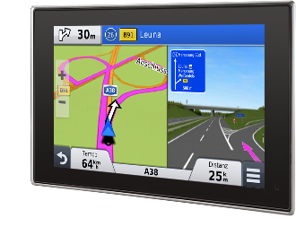
Garmin nüvi® x8 Serie
Überraschend pünktlich.
Umfahren Sie den Stau – mit unserem neuen Verkehrsservice über DAB+.
Erhalten Sie hochgenaue Verkehrsmeldungen in Echtzeit, und das doppelt
so schnell wie bei jedem anderen Verkehrsdienst. Ein Leben lang ohne
Folgekosten. Exklusiv bei Garmin.

Navigation der neuesten Generation: Erleben Sie 3D Traffic Live Echtzeit-Verkehrsinformationen via DAB+.
Profitieren Sie von Live-Verkehrsdaten ohne Folgekosten, von doppelt so schnellen Updates wie von jedem anderen Verkehrsdienst, von präzisen Anfangs- und Endpunkten von Verkehrsstörungen sowie einer komfortablen Out-of-the-box Lösung – ganz ohne extra Smartphone-Kopplung und -Halterung sowie nötige Datentarife.
3D Traffic Live - Mehr erfahren
Die nüvi® x8 Serie bietet zusätzlich viele weitere Highlights wie
Garmin Real Navigation, aktiven Fahrspurassistenten, Traffic
Splitscreen, gesprochenen Verkehrsnachrichten, PhotoReal™
3D-Kreuzungsansichten und natürlich die lebenslangen¹² Karten-Updates. Überzeugen Sie sich selbst ...
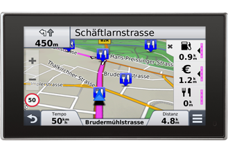
Die nüvi® x8 Serie mit 3D Traffic Live via DAB+
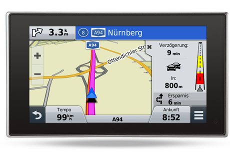
- Schnellere und exaktere Stauumfahrung – 3D Traffic Live via digitale Radiotechnik DAB+ liefert Echtzeit-Verkehrsinformationen ohne Folgekosten..
- Echte Sprachsteuerung
- Nie wieder nach dem Weg fragen – Garmin Real Navigation mit Garmin Real Directions™ und Garmin Real Voice™ geben realitätsnahe Navigationsanweisungen wie ein Beifahrer: "Links vor der Tankstelle abbiegen".
- Immer gute Karten – Bis zu viermal jährlich Updates für 22 bzw. 45 Länder Europas. Und das lebenslang³.
- Nichts verpassen – POIs entlang der Route, direkt ansteuerbar. Stellt Lieblings-POIs hervorgehoben dar, damit sie sich leicht wiederfinden lassen.
- Mehr Überblick – PhotoReal™ 3D- Kreuzungsansicht mit BirdsEye View. Zeigt komplexe Abbiegesituationen zur schnellen Orientierung genauso, wie man sie in Wirklichkeit vorfindet.
- Bluetooth Freisprecheinrichtung und Smartphone Link Kompatibilität
- Immer auf der richtigen Spur – Aktiver Fahrspurassistent unterstützt sicheres Abbiegen durch fortlaufend animierte Aktualisierung der Straßenführung.
ADVANCED-Serie
2448 · 2498 · 2548 · 2598 · 2798
Perfekte Orientierung Sie sind viel unterwegs und müssen sich auf Ihr
Navi verlassen können? Immer aktuelles und umfangreiches
Kartenmaterial, sicheres Fahren und perfekte Orientierung sind nur
einige Vorteile der Advanced-Modelle.
PREMIUM-Serie
3598
Nur das Beste ist gut genug Ausgezeichnetes Design und
High-End-Technologie ist die Grundvoraussetzung, damit ein mobiles Navi
in Ihr Auto kommt? Mit den Garmin Topmodellen mit schlankem Gehäuse,
Multitouch- Display und beeindruckender Bedienung fahren Sie weiter an
der Spitze!
3D Traffic Live über DAB+²So kommen Sie schneller ans Ziel. 3D Traffic Live via DAB+ ist ein neuer digitaler Echtzeit-Verkehrsservice ohne Folgekosten, aber mit doppelt so häufigen Updates wie andere Verkehrsdienste. Das Verkehrsaufkommen wird realistisch und präzise dargestellt, wodurch Ihnen kürzere Umfahrungsrouten vorgeschlagen werden können.Mehr erfahren |
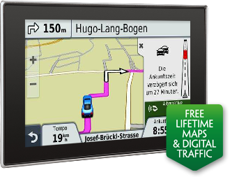
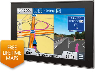
Lebenslange Kartenupdates³Immer auf dem aktuellen Stand. Mit kostenlosen lebenslangen Karten-Updates³ stehen Ihnen stets aktuelle Karten, Points of Interests und Navigationsinformationen zur Verfügung. Karten-Updates sind ohne Abonnement oder Gebühren bis zu 4 Mal pro Jahr verfügbar und laufen nicht ab. |
Echte SprachsteuerungDas nüvi® 3598LMT-D, 2598LMT-D und 2498LMT-D bietet den Luxus einer sprachgesteuerten Navigation. Sie können das Gerät mit Ihrer Stimme bedienen und beide Hände sicher am Lenkrad lassen. Natürlich kann aber auch mit Hilfe des Touchscreens navigiert werden. |
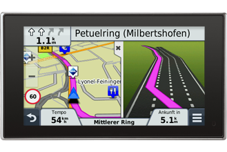
SplitscreensLassen Sie sich Verkehrsinformationen, Reisedaten, Kreuzungsansichten, uvm. anzeigen, ohne die Kartenansicht mit der aktuellen Route zu verlassen. Auch POIs entlang der Route lassen sich durch die hervorgehobene Darstellung im Splitscreen leicht finden. |
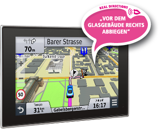
Real NavigationAnweisungen wie vom Freund auf dem Beifahrersitz. Garmin Real Navigation mit Garmin Real Directions™ und Real Voice™ sind natürliche Navigationsanweisungen anhand markanter, realer Punkte wie zum Beispiel Ampeln, Brücken, Tankstellen und auffälligen Gebäuden. Diese Anweisungen sind verständlicher und leichter zu befolgen. |
PhotoReal™ 3D Kreuzungsansicht und aktiver FahrspurassistentAuf der falschen Spur? Sprachansagen und Bewegtbilder im Splitscreen erleichtern das Einordnen in die richtige Spur auf komplizierten Kreuzungen und helfen Ihnen, sicher die nächste Ausfahrt zu nehmen. Die PhotoReal ™ 3D Kreuzungsansicht liefert außerdem eine fotorealistische Anzeige von Kreuzungen und Anschlussstellen. |
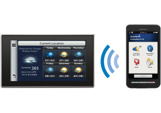
Smartphone Link¹Smartphone Link ermöglicht eine nahtlose Nutzung von Navigationsfunktionen auf einem kompatiblen Garmin-Navigationsgerät und einem Android oder iOS Smartphone. Die Geräte können Informationen wie gespeicherte oder kürzlich gefundene Positionen, die letzte Parkposition und das aktuelle Ziel austauschen. Zudem kann Ihr kompatibles nüvi® mit Garmin-Echtzeit-Diensten verknüpft werden. |
POIs entlang der RouteAuf der Suche nach einer Bank, einem Restaurant oder einer Tankstelle? POIs entlang der Route blendet POIs in der unmittelbaren Nähe ein. Lieblings-POIs entlang der Route werden hervorgehoben dargestellt und sind somit kinderleicht wiederzufinden. |
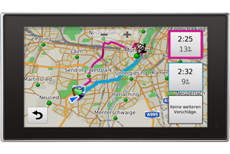
Alternative RoutenübersichtEigentlich wollten Sie eine andere Strecke fahren? Die alternative Routenübersicht ermöglicht es Ihnen verschiedene Routenalternativen auf einer Karte einzusehen und zu vergleichen, damit Sie sich die Route aussuchen können, die für Sie am besten passt. |
Bluetooth®
Verbinden Sie Ihr bluetoothfähiges Android oder iPhone- Mobiltelefon mit dem nüvi® 2498LMT-D, 2598LMT-D oder dem 3598LMT-D und nutzen Sie die Freisprechfunktion über das integrierte Mikrofon und die eingebauten Lautsprecher.
¹ Weitere Informationen zu den Daten- und Roaming-Tarifen erhalten Sie bei Ihrem Mobilfunkanbieter.
² Das kostenlose unbegrenzte Verkehrsfunkabonnement ist untrennbar mit dem Gerät verbunden und kann daher nicht auf andere Geräte übertragen werden. Wird das Gerät auf eine andere Person übertragen, wird damit auch die Lizenz für das unbegrenzte Verkehrsfunkabonnement übertragen. Verkehrsmeldungen können während der gesamten Nutzungsdauer des Verkehrsfunkempfängers von Garmin empfangen werden, d. h. solange Sie ein kompatibles GPS-Gerät von Garmin besitzen, oder bis Garmin keine Verkehrsdaten mehr vom Anbieter des Verkehrsfunkdienstes empfängt, je nachdem, welcher Zeitpunkt früher eintritt. Verkehrsfunk ist nicht in allen Gebieten verfügbar. Die "Nutzungsdauer" des Verkehrsfunkempfängers kennzeichnet den Zeitraum, in dem der Empfänger (a) die erforderlichen technischen Funktionen zur Nutzung aktueller Verkehrsfunkdienste aufweist und (b) wie vorgesehen funktionstüchtig ist, ohne dass umfangreiche Reparaturen erforderlich sind. Verkehrsfunk ist nicht in allen Gebieten verfügbar. Weitere Details finden Sie in den Informationen zu Gebieten, in denen Verkehrsmeldungen verfügbar sind.
³ Berechtigt den Nutzer zu jährlich bis zu vier Updates des Kartenmaterials solange er sein Navigationsgerät in Gebrauch hat oder Garmin Karten-Updates für dieses Datenformat anbietet, je nachdem was zuerst eintritt, längstens jedoch für die Dauer von dreißig Jahren. Das Recht ist nicht auf ein anderes Garmin Produkt übertragbar. Beachten Sie bitte die vollständigen Nutzungsbedingungen unter www.garmin.com/activatenumaps
Δευτέρα 14 Οκτωβρίου 2013
TopoNavigator 6 PC Αναβάθμιση 6.1.1
ΒΕΛΤΙΩΣΕΙΣ


1. Νεά ιδιότητα Επίπεδο Κλίμακας σε όλα τα δεδομένα του χρήστη. Με την ιδιότητα αυτή, ο χρήστης μπορεί να ελέγξει ποιά στοιχεία θα απεικονίζονται και σε ποιά κλίμακα. Η αρχική τιμή είναι 0, δηλαδή τα στοιχεία απεικονίζονται σε όλες τις κλίμακας. Ο έλεγχος της ιδιότητας μπορεί να γίνει είτε ανά στοιχείο (από τη φόρμα Ιδιοτήτων), είτε μαζικά (από τη φόρμα Ιδιοτήτων αρχείου). Όταν το Επίπεδο Κλίμακας ενός στοιχείου είναι μεγαλύτερο από το τρέχον Επίπεδο Κλίμακας του χάρτη, το στοιχείο δεν είναι ορατό και δεν μπορεί να επιλεχθεί ούτε από το χάρτη, ούτε από τον πίνακα. Στο δεξί κλίκ πάνω στην εγγραφή του στον πίνακα διατίθεται ένα μόνο μενού, η Αλλαγή Επιπέδου Κλίμακας, που ανοίγει τη φόρμα Ιδιοτήτων του στοιχείου, από την οποία μπορούμε να αλλάξουμε το Επίπεδο Κλίμακας και ξανακάνοντας ορατό το στοιχείο, και να προβούμε περαιτέρω σε οποιαδήποτε άλλη επεξεργασία.
2. Η ρύθμιση που ελέγχει την απεικόνιση όλου του αρχείου (καθορίζοντας ανεξάρτητα το ελάχιστο Επίπεδο Κλίμακας για την απεικόνιση όλων των διανυσμάτων του και της ονοματολογίας) διατηρείται και μεταφέρθηκε στην ενότητα Γενικά των ρυθμίσεων αρχείου.
3. Η αναζήτηση καλύπτει πλέον και τις παραλίες.
4. Η μεγέθυνση / σμίκρυνση με τα πλήκτρα F6/F7 επικεντρώνει στο κέντρο του ορατού τμήματος του χάρτη (και όχι στη θέση του ποντικιού, όπως γινόταν μέχρι τώρα). Το σημείο επικέντρωση υποδεικνύεται με το σχετικό σύμβολο.
5. Οι επιλογές προτεραιότητας των κατηγοριών οδικού δικτύου (έμφαση στους ασφάλτους/χωματόδρομους) και παλέτας (παλέτα Garmin / παλέτα Toponavigator) απαλείφθησαν από τις Ρυθμίσεις/GPS και σχετίσθηκαν εσωτερικά με το προφίλ χρήστη. Έτσι, όταν κατασκευάζεται ή επικαιροποιείται ο χάρτης για Garmin, λαμβάνεται υπόψην το τρέχον προφίλ χρήστη και η προτεραιότητα των κατηγοριών του οδικού δικτύου προσαρμόζεται ανάλογα.
Προφίλ: On Road, Θάλασσα, Πολιτισμός
Σχηματισμός χάρτη με έμφαση τους ασφάλτους και παλέτα TopoNavigator.
Προφίλ: Off Road, Adventure
Σχηματισμός χάρτη με έμφαση τους χωματόδρομους και παλέτα TopoNavigator.
Προφίλ: Ενέργειας
Σχηματισμός χάρτη με έμφαση τους ασφάλτους και παλέτα Garmin.
Σχηματισμός χάρτη με έμφαση τους ασφάλτους και παλέτα TopoNavigator.
Προφίλ: Off Road, Adventure
Σχηματισμός χάρτη με έμφαση τους χωματόδρομους και παλέτα TopoNavigator.
Προφίλ: Ενέργειας
Σχηματισμός χάρτη με έμφαση τους ασφάλτους και παλέτα Garmin.
6. Τα αρχεία back-up δεν φορτώνονται πλέον στο Διαχειριστή Αρχείων (για να μην γεμίζει ο πίνακας εγγραφές και να μην γίνει κατά λάθος επεξεργασία στο Backup_of_ αντί για το μητρικό αρχείο). Μπορεί πάντα κανείς να προσθέσει αυτοβούλως το Backup_of_xxx από την Προσθήκη Επιπέδου για οποιαδήποτε επεξεργασία.
7. Η οπτικοποίηση της εξέλιξης του κατεβάσματος των χαρτών του Κτηματολογίου γίνεται πλέον με μια εικαστική μπάρα προόδου (απεικονίονται κίτρινα τατραγωνάκια, ισάριθμα με τα πλακάκια που θα δημιουργηθουν - γίνονται πράσινα μόλις αποθηκευτεί το αντίστοιχο πλακάκι). Όταν ολοκληρωθεί το κατέβασμα μιας ενότητας, δημιουργείαι μια σχετική εγγραφή στο μενού των Χωροδεικτών, από την οποία μπορούμε να καλέσουμε μετέπειτα την περιοχή της ενότητας..
8. Δεκάδες βελτιώσεις σε δυσλειτουργίες και μικροατέλειες.
ΔΕΔΟΜΕΝΑ
Σημαντικές προσθήκες στον Παρνασσό, Αργολίδα, Μέθανα, Ήπειρο, Ναυπακτία, Ευρυτανία, Υμηττό κλπ..


Σάββατο 12 Οκτωβρίου 2013
University of Michigan Benchmarks Traffic Data: TomTom, Google, INRIX & Nokia

A University of Michigan study, commissioned by TomTom and published on Monday, has benchmarked real-time traffic systems from TomTom, Google, INRIX and Nokia HERE (on a Garmin device).
The University of Michigan Transportation Research Institute (UMTRI) undertook a ‘jam hunt analysis’, using six popular mobile apps and GPS devices to analyze the accuracy in reporting traffic congestion and incident data.
The following devices were used:
- TomTom PND: GO LIVE 2535M
- Garmin PNDs: Nuvi 1690 (SIM), Nuvi 3490 (HD), Nuvi 1695 (SIM) and Nuvi 3590 (HD), all using Nokia’s HERE Traffic
- TomTom App: Version 1.14
- Google App: Version 1.1.6
- Inrix App: Version 4.5.1
The “jam hunt analysis“ was performed by two test vehicles equipped with all of the navigation devices and apps. Each vehicle then drove through a total of approximately 165 traffic jams. The information reported on each system was recorded on video and coded into statistics on the accuracy of each real time traffic service.
“By driving through the same traffic jams with each device simultaneously, our study identified the accuracy of each GPS system in reporting congestion, with varying results across the board,” said Bruce M. Belzowski, Assistant Research Scientist from the University of Michigan. “Overall, TomTom’s device and app reported the most accurate traffic information.”
The results can been seen in the table below (full report available at the end of the article).
Limitations of the benchmark
While the benchmark has been made with a very scientific approach, one can however make two comments about the benchmark.
First the tests have been performed uniquely the Detroit area. a traffic provider can be better here and worst there based on its number of probes and other local specificities. The same test in another U.S. metropolitan area could possibly provide different results.
Second it is clear that the Garmin devices (with Nokia traffic) perform poorly in the test, however there are reasons to that. The first one is that the two devices Nuvi 1690 and Nuvi 1695 are outdated, they have been launched late 2009 and late 2010 respectively.
As it comes to the more recent NUVI 3490 and 3590 they both use HD Radio as communication technology which has more limitations than the cellular technology used in the TomTom PND or the 3G connection of the smatphones running the mobile apps in the test.

Τετάρτη 2 Οκτωβρίου 2013
Flinc on NAVIGON Android (Greek photos)
Δύο screenshot απο το NAVIGON Android.....
.......με το εικονίδιο του Flinc αριστερά...

.....και όταν το επιλέξουμε, έχουμε την παρακάτω εικόνα..

....χρειάζεται δωρεάν εγγραφή για να χρησιμοποιήσετε την υπηρεσία.
.......με το εικονίδιο του Flinc αριστερά...
.....και όταν το επιλέξουμε, έχουμε την παρακάτω εικόνα..
....χρειάζεται δωρεάν εγγραφή για να χρησιμοποιήσετε την υπηρεσία.
Τρίτη 1 Οκτωβρίου 2013
BMW Motorrad Navigator V Provides Access to Real-Time Motorcycle Information

Today we announced the new BMW Motorrad Navigator V. This new navigator is designed for BMW motorcycles and combines the latest Garmin navigation features with exclusive, BMW-specific functions, such as a customized mount, access to real-time motorcycle information[1], advanced audio and Bluetooth capabilities, and more.
“Our partnership with BMW Motorrad has proven very successful over the last 11 years and we’re thrilled to introduce this next-generation BMW Motorrad Navigator,” said Ulrich Niedermayr, automotive OEM account executive at Garmin Deutschland GmbH. “The BMW Motorrad Navigator V goes far beyond providing simple road guidance by giving riders instant access to real-time motorcycle data, extensive route planning capabilities and advanced audio and Bluetooth functionalities.”
BMW Navigator V features a large 5” display that is glove-friendly and makes navigation information visible at a glance. The integrated stereo Bluetooth functionality lets riders hear navigation prompts, answer calls or listen to music through their helmet. On select BMW motorcycles, riders can even view comprehensive real-time information1 on the MyMotorcycle Pages, such as tire pressure, gas levels, and when their next service is. The system also tells the rider how many times he shifted gears, used the front or rear brakes, the average throttle position, and more1. The page can be configured for multiple data field layouts and users can re-arrange the data in the order they would like to see. With the Last Ride Analyzer users can view a summary of the motorcycle data, trip conditions and stats of their last ride.
Premium Garmin navigation features include Active Lane Guidance, Real Directions, junction views, 3D terrain, and more. Garmin Real Directions™ guide riders in a natural and intuitive way. The new feature uses recognizable landmarks, buildings, traffic lights and stop signs to give directions. For example, it tells riders to “turn right after the Starbucks®” or “turn left at the traffic light.” The new Active Lane Guidance displays an animated graphic next to the map view that uses brightly colored arrows to indicate the proper lane needed to make a turn. PhotoNavigation allows riders to simply click on a geo-coded picture stored on the device to start navigating to that destination. When purchased with maps for Europe or North America, Motorrad Navigator V includes lifetime map updates[2].
Even before riders get on their motorcycle, they can conveniently plan out their trips in advance using the BaseCamp trip planning desktop software, creating longer and more detailed tours with up to 3,750 shaping points per trip. Trips can easily transferred to the navigation device via USB.
BMW Navigator V is compatible with Garmin Smartphone Link, an Android and iPhone app that provides riders access to live services[3], such as traffic camera images, weather and fuel prices, utilizing the smartphone's mobile data plan.
The BMW Navigator V comes with a BMW exclusive, four-button motorcycle mount that enables many quick-key functions for extra control and usability. The mount and GPS device are vibration-tested, waterproof (IPX-7 standards[4]), and designed to withstand fuel sprays and UV rays. On R 1200 GS and K 1600 GT / GTL models with factory-installed navigation option many functions can also be controlled directly using the multi-controller on the left handlebar.
BMW Motorrad Navigator V is available now at BMW Motorrad dealers in Europe and North America.
[1]Available on select BMW motorcycles.
[2]Lifetime Maps entitle you to receive map updates when and as such updates are made available by Garmin during the useful life of 1 compatible Garmin product or as long as Garmin receives map data from a third party supplier, whichever is shorter. For the meaning of a product’s “useful life” and for other important terms and conditions, please see www.garmin.com/numapslifetime.
[3]Restrictions apply. Not available in all areas. Subscriptions required. Contact your mobile service provider for more information about your service plan's data and roaming rates. See http://static.garmincdn.com/pumac/Premium_Content_EN.htm for terms, conditions and limitations.
[4]Device will withstand incidental exposure to water of up to one meter of depth for 30 minutes.
Εγγραφή σε:
Αναρτήσεις (Atom)