
NaviFree : Νέα από τον χώρο της πλοήγησης των συσκευών GPS & Smartphones καθώς πολλά Tip's & Tricks NaviFree : News from the NAVIGATION sector, GPS devices, smartphones navigation, and many Tips & Tricks NaviFree: News aus der Navigation, GPS-Geräte, Smartphones Navigation und vielen Tipps & Tricks . NaviFree :记者从导航领域,GPS设备,智能导航,和许多提示和技巧
Τετάρτη 31 Δεκεμβρίου 2014
Σάββατο 27 Δεκεμβρίου 2014
Garmin nüvi 2599 LMT-D
Garmins aktuelle nüvi Advanced x9er
Serie im ausführlichen Test! Drei Modelle – nüvi 2569 LMT-D, nüvi 2599
LMT-D, nüvi 2699 LMT-D – sind bereits erhältlich, im Frühjahr 2015 stößt
noch das nüvi 2799 LMT-D dazu.
Alle Advanced x9er nüvis empfangen Verkehrsnachrichten via digitaler Radiotechnik (DAB+) oder via Bluetooth & Smartphone, bieten kapazitive Echtglas-Displays (2569LMT-D/2599LMT-D: 5-Zoll, 2699LMT-D: 6-Zoll, 2799LMT-D: 7-Zoll), Bluetooth-Freisprecheinrichtungen, Sprachsteuerung (nicht 2569 LMT-D), Karten von Gesamt-Europa (2569 LMT-D nur Zentral-Europa) und kostenlose lebenslange Karten-Updates. Die Verkaufspreise (UVP) liegen bei: €199.- (2569LMT-D), €219.- (2599LMT-D), €249.- (2699LMT-D) bzw. €319.- Euro (2799LMT-D).
Für den Test haben wir uns das zu einem Straßenpreis von 199.- Euro erhältliche nüvi 2599 LMT-D herausgepickt. Die Testergebnisse sind auf alle Advanced x9er nüvis übertragbar.

Die mitgelieferte Halterung ist sehr kurz gebaut, je nach Befestigungspunkt kann das nüvi deshalb schon einmal außer Reichweite des Fahrers geraten. Macht aber nichts, schließlich gibt es elegante Lösungen. Mittels Armaturenbrett-Klebeplatten läßt sich die Saugnapfhalterung an einer ebenen Fläche befestigen (ein dauerhafter Halt ist aber nicht bei jeder Oberflächenstruktur gegeben), mit einer Lüftungshalterung läßt sich das nüvi im Cockpit verstecken. Was es leider auch als Zubehör nicht gibt: eine Aktivhalterung.
Der Akku des nüvi 2599LMT-D hält rund 01:45 hh:mm durch (maximale Helligkeitseinstellung). Das Ladekabel sorgt nicht nur für Energie, sondern durch den integrierten Empfänger auch für Verkehrsmeldungen. Wer kabellos fahren und trotzdem Verkehrsnachrichten empfangen möchte, muss das 2599LMT-D per Bluetooth mit einem Android- oder iOS-Smartphone koppeln. Vorausgesetzt, auf dem Smartphone ist die App “Garmin Smartphone Link” installiert. Das initiale Bluetooth-Pairing und das wiederholte Verbinden mit einem Smartphone gehen ohne Schwierigkeiten über die Bühne.
Der GPS-Empfang ist excellent, die Positionsdaten stehen kurz nach dem Einschalten des Gerätes zur Verfügung. Ein Vorteil, der sich insbesondere beim Ausfahren aus einem Parkhaus oder einer Tiefgarage positiv bemerkbar macht! Das nüvi reagiert schnell und verzögerungsfrei, dank des kapazitiven Displays läßt sich die Karte per 2-Finger-Zoomfunktion elegant vergrößern bzw. verkleinern. Lediglich das Berechnen von Routen dauert etwas länger als bei manchem Mitbewerber.
Die Sprachsteuerung wird mittels eines individuell konfigurierbaren Sprachbefehls wie z.B. “Hallo Garmin” gestartet. Sie funktioniert bei moderaten Nebengeräuschen sehr gut, die Geräuschkulisse wirkt sich insbesondere auf die Erfolgsquote beim Suchen von Adressen aus. Besonders hervorzuheben sind die einfache, intuitive Nutzung und die durchgängige Befehlsabfolge vom Suchen einer Adresse bis hin zum Starten der Navigation oder dem Führen eines Telefonats inklusive der Auswahl einer Nummer aus dem Telefonbuch.

Zum Eingeben von Zielen stehen alle üblichen Funktionen zur Verfügung (auf der Karte, Koordinaten etc.). Beim Tippen von Adressen fällt auf, dass z.B. Hamburg als erster Vorschlag erst nach einem Tippen von “Hambu” auftaucht. Dies geht besser, Becker-Navis listen Hamburg schon beim “H” auf. Dies ist aber eine Kleinigkeit, vor allem in Anbetracht der Tatsache, welche Möglichkeiten es sonst noch gibt. Bei der Suche nach Tankstellen werden bei gekoppeltem Smartphone die aktuellen Preise angezeigt, die Suche mit Foursquare bietet viele POIs in Verbindung mit interessanten Kategorien wie “Das Beste in der Nähe” oder “Angesagt“.
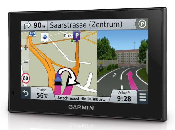
Der Navigationsbildschirm wirkt überfrachtet. Oben, unten, rechts, links – überall stehen Informationen. Durch Ausblenden der Infoleiste rechts von der Karte wird die Situation etwas besser, dann fehlen aber wichtige Informationen. Unterhalb der Karte werden schließlich nur die Geschwindigkeit (nicht änderbar) und in einem weiteren Datenfeld z.B. die Ankunftszeit (konfigurierbar, 10 Datentypen stehen zur Auswahl) angezeigt. Wer gleichzeitig noch weitere Daten wie z.B. die Restdistanz oder die voraussichtliche Fahrtzeit im Blick haben möchte, ist auf die Infoleiste angewiesen. Anstelle der Reisedaten lassen sich in der Infoleiste z.B. auch POIs entlang der Route oder Wettermeldungen anzeigen; Verkehrshinweise werden in der Leiste automatisch eingeblendet.
Die zu fahrende Strecke wird wie bei Garmin üblich in einem kräftigen, gut erkennbaren Magenta dargestellt. Die Karte bietet eine sehr gute Übersicht über die vorausliegende Strecke und unterstützt damit ein vorausschauendes Fahren. Sehr nützlich sind die temporär rechts von der Karte auftauchenden, realistischen Darstellungen von Autobahnkreuzen oder Ausfahrten.
Für die Sprachansagen stehen mehrere Stimmen zur Auswahl, unter anderem Anna und Yannick mit der Funktion Garmin Real Direction. Dahinter verbergen sich hilfreiche Hinweise wie “an der Ampel rechts abbiegen” und die Ansage von Straßennamen. Die Ansagen sind gut verständlich. Über die Häufigkeit läßt sich diskutieren; manchmal ertönen sie an Stellen, wo sie schlichtweg nicht nötig sind und fehlen dafür woanders. Zudem fällt auf, dass die Entfernungsangaben in den Sprachansagen von den Entfernungsangaben auf dem Bildschirm abweichen können. Aber auch beim nüvi 2599LMT-D gilt: Hat man sich erst einmal an die Ansagen gewöhnt, lässt sich damit sicher navigieren!
Zum Berechnen von Routen stehen mehrere Methoden zur Auswahl: kürzere Zeit, Luftlinie, kürzere Strecke, weniger Kraftstoff. Wer mag kann zusätzlich die Funktion trafficTrends aktivieren; dann werden bei der Routenberechnung historische Verkehrsdaten berücksichtigt. Im Test wurde sich auf die Kombination “kürzere Zeit” und “trafficTrends” konzentriert. “Kürzere Zeit” ist von Autofahrern sicherlich die am häufigsten gewählte Methode und historische Verkehrsdaten sind generell eine sinnvolle Grundlage zum Optimieren von Strecken.
Was fällt auf? Bei innerstädtischen Fahrten geht es selbst zu staulosen Zeiten eher mal auf einer mit Ampeln gespickten Strecke mittendurch als außen herum, bei einer Tour über Land wird teils eine deutlich längere Strecke via Autobahn und Bundesstraße statt eine zeitgleiche Strecke via Bundes-/Landstraße gewählt. Beispiel: Nach der Zieleingabe wird eine Route mit 23 km und 13:53 mm:ss Fahrtzeit berechnet (über Autobahn und Landstraße); beim Berechnen einer Alternativroute kommt ein Vorschlag mit 13 km und 13:52 mm:ss heraus (über Landstraße)!
Im Vergleich zu Navis von TomTom und Becker fallen manche Strecken eher ungewöhnlich aus, als Einheimischer würde man sie auch nicht nehmen. Bei langen Autobahnstrecken gibt es hingegen nichts zu kritisieren.
Wem die Strecke nicht passt, kann sich bis zu zwei Alternativrouten berechnen lassen. Hier fällt auf, dass das nüvi manchmal keine oder nur eine Alternative vorschlägt.
Erste Meldungen werden bereits kurz nach dem Einschalten des nüvis empfangen, sehr gut umgesetzt ist auch die optische und akustische Integration in die Navigation. Die Verkehrsmeldungen stimmen in der Regel sehr gut mit der Realität überein, selbst kleine Verzögerungen werden präzise angezeigt.

Ein wichtiges Thema sind Warnungen bei Geschwindigkeitsüberschreitungen und vor Blitzern. Bei Tempoalarmen gibt es nur an oder aus, auf individuelle Toleranzbereiche (z.B. “warne mich innerorts bei einer Überschreitung von 10 km/h“) verzichtet Garmin.
Wer dauerhaft vor Blitzern gewarnt werden möchte, muss ein Cyclops Radar-Info Paket kaufen. Die Kosten belaufen sich für ein Jahresabo auf €19,95 (Deutschland & Österreich) bzw. €29,95 (Europa)(alternativ: einmaliger Download bzw. weitere Länder). Es gibt auch eine kostenlose Testversion und wer bis zum 31.12.2014 ein 2599LMT-D kauft, erhält ein kostenloses 2 Jahresabo für Europa. Die Aktualisierung der Radar-Datenbank auf dem nüvi erfolgt via USB-Kabel und PC.
Was in der Praxis nicht gefällt und durchaus nervt, sind die häufigen Warnungen vor mobilen Blitzern. Dahinter stecken irgendwann einmal in die Datenbank aufgenommene Standorte, die allenfalls als Hinweise auf mögliche Blitzer anzusehen sind.
Eine schöne Ergänzung sind die Funktionen, die via Garmin Smartphone Link zur Verfügung stehen (für iOS und Android). Dahinter stecken kostenlose Dienste wie eine erweiterte Foursquare-Suche, Speichern der Parkposition, Wetter-Meldungen, Übertragen von Positionen/Suchergebnissen/Kontakten auf das nüvi, Live-Verkehrsdaten und kostenpflichtige Dienste wie detaillierte Infos zu Parkplätzen/-häusern.
Zu erwähnen sind noch Vorteile wie das schnelle und unkomplizierte Aktualisieren des Kartenmaterials im Rahmen der lebenslangen kostenlosen Karten-Updates (insbesondere im Vergleich zu TomTom und Becker) und das einfache Hinzufügen von eigenen POIs.
Alle Advanced x9er nüvis empfangen Verkehrsnachrichten via digitaler Radiotechnik (DAB+) oder via Bluetooth & Smartphone, bieten kapazitive Echtglas-Displays (2569LMT-D/2599LMT-D: 5-Zoll, 2699LMT-D: 6-Zoll, 2799LMT-D: 7-Zoll), Bluetooth-Freisprecheinrichtungen, Sprachsteuerung (nicht 2569 LMT-D), Karten von Gesamt-Europa (2569 LMT-D nur Zentral-Europa) und kostenlose lebenslange Karten-Updates. Die Verkaufspreise (UVP) liegen bei: €199.- (2569LMT-D), €219.- (2599LMT-D), €249.- (2699LMT-D) bzw. €319.- Euro (2799LMT-D).
Für den Test haben wir uns das zu einem Straßenpreis von 199.- Euro erhältliche nüvi 2599 LMT-D herausgepickt. Die Testergebnisse sind auf alle Advanced x9er nüvis übertragbar.
Garmin nüvi 2599 LMT-D mit Real Direction Anzeige (Bild: Garmin)
Garmin nüvi 2599 LMT-D Test: Technik
Das Garmin gute Hardware baut ist bekannt. Und das nüvi 2599LMT-D macht da keine Ausnahme. Das Kunststoffgehäuse hinterlässt einen hochwertigen Eindruck. Das kapazitive Echtglas-Display trägt genauso seinen Teil zur schicken Optik bei wie die flache Bauweise (1,8 cm) und die moderaten Außenabmessungen (13,8 x 8,4 cm). Ein weiteres schönes Detail: Der USB-Anschluß befindet sich auf der Gehäuserückseite, somit steht kein störender USB-Stecker an der Seite hervor.Die mitgelieferte Halterung ist sehr kurz gebaut, je nach Befestigungspunkt kann das nüvi deshalb schon einmal außer Reichweite des Fahrers geraten. Macht aber nichts, schließlich gibt es elegante Lösungen. Mittels Armaturenbrett-Klebeplatten läßt sich die Saugnapfhalterung an einer ebenen Fläche befestigen (ein dauerhafter Halt ist aber nicht bei jeder Oberflächenstruktur gegeben), mit einer Lüftungshalterung läßt sich das nüvi im Cockpit verstecken. Was es leider auch als Zubehör nicht gibt: eine Aktivhalterung.
Der Akku des nüvi 2599LMT-D hält rund 01:45 hh:mm durch (maximale Helligkeitseinstellung). Das Ladekabel sorgt nicht nur für Energie, sondern durch den integrierten Empfänger auch für Verkehrsmeldungen. Wer kabellos fahren und trotzdem Verkehrsnachrichten empfangen möchte, muss das 2599LMT-D per Bluetooth mit einem Android- oder iOS-Smartphone koppeln. Vorausgesetzt, auf dem Smartphone ist die App “Garmin Smartphone Link” installiert. Das initiale Bluetooth-Pairing und das wiederholte Verbinden mit einem Smartphone gehen ohne Schwierigkeiten über die Bühne.
Der GPS-Empfang ist excellent, die Positionsdaten stehen kurz nach dem Einschalten des Gerätes zur Verfügung. Ein Vorteil, der sich insbesondere beim Ausfahren aus einem Parkhaus oder einer Tiefgarage positiv bemerkbar macht! Das nüvi reagiert schnell und verzögerungsfrei, dank des kapazitiven Displays läßt sich die Karte per 2-Finger-Zoomfunktion elegant vergrößern bzw. verkleinern. Lediglich das Berechnen von Routen dauert etwas länger als bei manchem Mitbewerber.
Garmin nüvi 2599 LMT-D Test: Freisprecheinrichtung, Sprachsteuerung
Eine Bluetooth-Freisprecheinrichtung gehört bei PNDs zu den beliebten Funktionen. Die Integration der Freisprecheinrichtung in die Benutzeroberfläche ist beim nüvi 2599LMT-D genauso überzeugend wie die Navi-seitige Sprachqualität; Anrufer berichten dagegen von einem störenden Hallen. Längere Telefonate lassen sich aber durchaus führen.Die Sprachsteuerung wird mittels eines individuell konfigurierbaren Sprachbefehls wie z.B. “Hallo Garmin” gestartet. Sie funktioniert bei moderaten Nebengeräuschen sehr gut, die Geräuschkulisse wirkt sich insbesondere auf die Erfolgsquote beim Suchen von Adressen aus. Besonders hervorzuheben sind die einfache, intuitive Nutzung und die durchgängige Befehlsabfolge vom Suchen einer Adresse bis hin zum Starten der Navigation oder dem Führen eines Telefonats inklusive der Auswahl einer Nummer aus dem Telefonbuch.

Hauptmenü nüvi 2599 LMT-D (rechts im Bild)
Garmin nüvi 2599 LMT-D Test: Bedienung, Navigation, Routen
An die nüvi 2599LMT-D Bedienung muss man sich gewöhnen! Wo welche Funktionen sind erschließt sich erst mit der Zeit – und an Funktionen mangelt es dem 2599LMT-D nicht! Ist diese Hürde genommen, läßt sich das nüvi im Zusammenspiel mit dem sensitiven Display sehr flott und elegant bedienen.Zum Eingeben von Zielen stehen alle üblichen Funktionen zur Verfügung (auf der Karte, Koordinaten etc.). Beim Tippen von Adressen fällt auf, dass z.B. Hamburg als erster Vorschlag erst nach einem Tippen von “Hambu” auftaucht. Dies geht besser, Becker-Navis listen Hamburg schon beim “H” auf. Dies ist aber eine Kleinigkeit, vor allem in Anbetracht der Tatsache, welche Möglichkeiten es sonst noch gibt. Bei der Suche nach Tankstellen werden bei gekoppeltem Smartphone die aktuellen Preise angezeigt, die Suche mit Foursquare bietet viele POIs in Verbindung mit interessanten Kategorien wie “Das Beste in der Nähe” oder “Angesagt“.
Der Navigationsbildschirm wirkt überfrachtet. Oben, unten, rechts, links – überall stehen Informationen. Durch Ausblenden der Infoleiste rechts von der Karte wird die Situation etwas besser, dann fehlen aber wichtige Informationen. Unterhalb der Karte werden schließlich nur die Geschwindigkeit (nicht änderbar) und in einem weiteren Datenfeld z.B. die Ankunftszeit (konfigurierbar, 10 Datentypen stehen zur Auswahl) angezeigt. Wer gleichzeitig noch weitere Daten wie z.B. die Restdistanz oder die voraussichtliche Fahrtzeit im Blick haben möchte, ist auf die Infoleiste angewiesen. Anstelle der Reisedaten lassen sich in der Infoleiste z.B. auch POIs entlang der Route oder Wettermeldungen anzeigen; Verkehrshinweise werden in der Leiste automatisch eingeblendet.
Die zu fahrende Strecke wird wie bei Garmin üblich in einem kräftigen, gut erkennbaren Magenta dargestellt. Die Karte bietet eine sehr gute Übersicht über die vorausliegende Strecke und unterstützt damit ein vorausschauendes Fahren. Sehr nützlich sind die temporär rechts von der Karte auftauchenden, realistischen Darstellungen von Autobahnkreuzen oder Ausfahrten.
Für die Sprachansagen stehen mehrere Stimmen zur Auswahl, unter anderem Anna und Yannick mit der Funktion Garmin Real Direction. Dahinter verbergen sich hilfreiche Hinweise wie “an der Ampel rechts abbiegen” und die Ansage von Straßennamen. Die Ansagen sind gut verständlich. Über die Häufigkeit läßt sich diskutieren; manchmal ertönen sie an Stellen, wo sie schlichtweg nicht nötig sind und fehlen dafür woanders. Zudem fällt auf, dass die Entfernungsangaben in den Sprachansagen von den Entfernungsangaben auf dem Bildschirm abweichen können. Aber auch beim nüvi 2599LMT-D gilt: Hat man sich erst einmal an die Ansagen gewöhnt, lässt sich damit sicher navigieren!
Zum Berechnen von Routen stehen mehrere Methoden zur Auswahl: kürzere Zeit, Luftlinie, kürzere Strecke, weniger Kraftstoff. Wer mag kann zusätzlich die Funktion trafficTrends aktivieren; dann werden bei der Routenberechnung historische Verkehrsdaten berücksichtigt. Im Test wurde sich auf die Kombination “kürzere Zeit” und “trafficTrends” konzentriert. “Kürzere Zeit” ist von Autofahrern sicherlich die am häufigsten gewählte Methode und historische Verkehrsdaten sind generell eine sinnvolle Grundlage zum Optimieren von Strecken.
Was fällt auf? Bei innerstädtischen Fahrten geht es selbst zu staulosen Zeiten eher mal auf einer mit Ampeln gespickten Strecke mittendurch als außen herum, bei einer Tour über Land wird teils eine deutlich längere Strecke via Autobahn und Bundesstraße statt eine zeitgleiche Strecke via Bundes-/Landstraße gewählt. Beispiel: Nach der Zieleingabe wird eine Route mit 23 km und 13:53 mm:ss Fahrtzeit berechnet (über Autobahn und Landstraße); beim Berechnen einer Alternativroute kommt ein Vorschlag mit 13 km und 13:52 mm:ss heraus (über Landstraße)!
Im Vergleich zu Navis von TomTom und Becker fallen manche Strecken eher ungewöhnlich aus, als Einheimischer würde man sie auch nicht nehmen. Bei langen Autobahnstrecken gibt es hingegen nichts zu kritisieren.
Wem die Strecke nicht passt, kann sich bis zu zwei Alternativrouten berechnen lassen. Hier fällt auf, dass das nüvi manchmal keine oder nur eine Alternative vorschlägt.
Garmin nüvi 2599 LMT-D Test: Verkehrsmeldungen
Bei den Verkehrsmeldungen setzt Garmin auf Nokia HERE Traffic. Der Empfang erfolgt per digitaler Radiotechnik (DAB+). In der bevorzugten Testregion Oberbayern gab es keinerlei Probleme mit der DAB+ Abdeckung. Falls DAB+ nicht zur Verfügung steht, dient Premium TMC (vormals TMCpro) über RDS-TMC als Fallback-Option. Garmin Live Traffic via Smartphone ist eine weitere Möglichkeit, um das nüvi mit aktuellen Nachrichten zu versorgen.Erste Meldungen werden bereits kurz nach dem Einschalten des nüvis empfangen, sehr gut umgesetzt ist auch die optische und akustische Integration in die Navigation. Die Verkehrsmeldungen stimmen in der Regel sehr gut mit der Realität überein, selbst kleine Verzögerungen werden präzise angezeigt.

nüvi 2599LMT-D: Verkehrsmeldung auf der Karte und in der Infoleiste
rechts am Bildschirm; gute Übersicht über die vorausliegende Strecke.
Garmin nüvi 2599 LMT-D Test: Funktionen
Funktionen bietet das nüvi 2599LMT-D in Hülle und Fülle. Neben den bereits erwähnten Funktionen gibt es z.B. noch: Planen von Mehrzielrouten inklusive Routenoptimierung, Festlegen der Parkposition, ecoRoute zum Berechnen der Kraftstoffkosten und Optimieren des Spritverbrauchs, “Wo bin ich” (Angaben zu Standort, Adresse etc.), “Wo war ich?” (Reisetagebuch), Aufzeichnen der zurückgelegten Strecke, Sperren von Streckenabschnitten, einfaches Hinzufügen von Zwischenzielen, Reisecomputer mit zwei Zählern.Ein wichtiges Thema sind Warnungen bei Geschwindigkeitsüberschreitungen und vor Blitzern. Bei Tempoalarmen gibt es nur an oder aus, auf individuelle Toleranzbereiche (z.B. “warne mich innerorts bei einer Überschreitung von 10 km/h“) verzichtet Garmin.
Wer dauerhaft vor Blitzern gewarnt werden möchte, muss ein Cyclops Radar-Info Paket kaufen. Die Kosten belaufen sich für ein Jahresabo auf €19,95 (Deutschland & Österreich) bzw. €29,95 (Europa)(alternativ: einmaliger Download bzw. weitere Länder). Es gibt auch eine kostenlose Testversion und wer bis zum 31.12.2014 ein 2599LMT-D kauft, erhält ein kostenloses 2 Jahresabo für Europa. Die Aktualisierung der Radar-Datenbank auf dem nüvi erfolgt via USB-Kabel und PC.
Was in der Praxis nicht gefällt und durchaus nervt, sind die häufigen Warnungen vor mobilen Blitzern. Dahinter stecken irgendwann einmal in die Datenbank aufgenommene Standorte, die allenfalls als Hinweise auf mögliche Blitzer anzusehen sind.
Eine schöne Ergänzung sind die Funktionen, die via Garmin Smartphone Link zur Verfügung stehen (für iOS und Android). Dahinter stecken kostenlose Dienste wie eine erweiterte Foursquare-Suche, Speichern der Parkposition, Wetter-Meldungen, Übertragen von Positionen/Suchergebnissen/Kontakten auf das nüvi, Live-Verkehrsdaten und kostenpflichtige Dienste wie detaillierte Infos zu Parkplätzen/-häusern.
Zu erwähnen sind noch Vorteile wie das schnelle und unkomplizierte Aktualisieren des Kartenmaterials im Rahmen der lebenslangen kostenlosen Karten-Updates (insbesondere im Vergleich zu TomTom und Becker) und das einfache Hinzufügen von eigenen POIs.
Παρασκευή 26 Δεκεμβρίου 2014

Τετάρτη 17 Δεκεμβρίου 2014
25 Jahre Navi: Von der Landkarte auf Kassette bis zu Daten aus der Cloud
Früher war der Straßen*atlas unver*zichtbar bei Reisen mit dem Auto.
Seit den 1990er Jahren lotsen jedoch Navis die Autofahrer von A nach B.
Ein Viertel*jahr*hundert nach ihrem Start stehen die Helfer*lein
ihrer*seits vor einer Ablösung.
"Drehen Sie wenn möglich um", "Abfahrt vor Ihnen" oder auch "Sie haben Ihr Ziel erreicht": Aussagen wie diese sind vielen Autofahrern heute gut bekannt, dem Navigationssystem sei Dank. Das Navigationsgerät, kurz Navi genannt, für die Straße hat seine Wurzeln im niedersächsischen Hildesheim. Dort entwickelte Bosch in den 1980er Jahren bei seiner damaligen Tochter Blaupunkt das nach Firmenangaben weltweit erste Navi für den Straßenverkehr. Der Prototyp hatte 1983 den Namen Eva - "Elektronischer Verkehrslotse für Autofahrer". Seine Landkarte war seinerzeit noch auf einer Kassette gespeichert - und deren Datenvolumen reichte gerade einmal für die Hildesheimer Innenstadt. Der Siegeszug der CD erlaubte dann mehr.
Erste
Positionspapiere zu "Zielführungssystemen" hatten Ingenieure bei Bosch
und Blaupunkt in Hildesheim bereits 1978 vorgelegt, wie der schwäbische
Konzern berichtet. Nach "Eva" folgte dann bei Bosch mit dem sogenannten
TravelPilot 1989 das erste serienreife Auto-Navi für den Straßenverkehr
in Europa. Laut Bosch war dieses System keine Weltpremiere, da in Japan
parallel eine ähnliche Erfindung lief.
Navis: Damals und heute
Der Anfang moderner Navigation im Auto erinnert an die gute alte Seefahrt. Denn 1989 beim Start des Navi im PKW führte noch ein Kompass Regie. Der Autozulieferer Bosch bot damals Bausätze zur Navi-Nachrüstung an, bei denen Radsensoren und ein Kompass ihre Informationen in gespeicherte Straßenkarten einspeisten. Heute, 25 Jahre später, lenken längst Satellitenpositionsdaten (GPS) die Navis. Und die haben inzwischen harte Konkurrenz bekommen: Smartphones. Der einst jahrelang boomende Navi-Markt befindet sich im Umbruch.
Während Boschs Navi-Pionier 1989 noch rund 7 000 D-Mark kostete, gibt heutzutage die Stiftung Warentest mobilen Navigationsgeräten zum An-die-Scheibe-Heften für nur 130 Euro schon die Note "gut". Mitte der 1990er Jahre, als bereits GPS die Richtung vorgab, kostete das Navi von Bosch noch 4 000 D-Mark. Zu haben war es als Serien-Extra in den Flaggschiffen S-Klasse von Mercedes und 7er-BMW. Zu den ersten Großkunden für die Technik, die Bosch im niedersächsischen Hildesheim entwickelte, gehörten damals professionelle Fahrzeugflotten. Etwa die Feuerwehr Los Angeles oder hierzulande die Post und Rettungsdienste. Die Entwicklung lief damals in Europa und Japan parallel, Bosch kam dann 1989 mit dem ersten Navi für Europa.
Smartphones machen klassischen Navis Druck
Inzwischen steuert das Navi nicht nur bei Bosch in eine Zeitenwende. Ein Treiber dabei sind internetfähige Handys. So betont etwa der Navi-Riese Garmin, der für VW und Daimler arbeitet: "Das Geschäft mit Navigationsgeräten steht wegen leistungsfähiger Smartphone-Anwendungen unter hohem Druck." Die mobilen Telefone ermöglichen die Offboard- und Onboard-Navigation mittels GPS und oftmals auch Glonass ebenso zuverlässig wie klassische Navigationsgeräte. Navi-Hersteller wie TomTom oder Navigon bieten daher auch entsprechende Smartphone-Apps für die Betriebssysteme Android, iOS und Windows Phone an.
Aufgrund der zunehmenden Navigation mit dem Smartphone verkaufte Garmin im dritten Quartal 2014 abermals weniger Navis. Der Umsatz im dazugehörigen Segment der Bilanz sank um fünf Prozent. Auch bei der Branchengröße TomTom schrumpft das Geschäft, zumindest bei tragbaren Navis zum Befestigen im Wageninneren. Die Umsätze sind dort bereits "seit einigen Jahren" rückläufig, wie die jüngste Bilanz festhält. TomTom sieht ähnlich wie Garmin zwei Gründe: Fest eingebaute Navis sind zunehmend zentraler Teil der Auto-Cockpits und werden dort zum Standard - der Weg vieler einst luxuriöser Extras.
Bei diesem Effekt verweist Autobranchenexperte Stefan Bratzel auf die bekannte Sicherheitstechnik wie Gurt, Airbags, Antiblockiersystem ABS oder Schleuderschutz ESP. "Solche Extras diffundieren von der Oberklasse in die breite Masse und werden am Ende oft gesetzlicher Standard", sagt er. Ein junges Beispiel sei der Notbremsassistent, der Gefahren im Stadtverkehr erkennt und automatisch selber bremst.
Diese Notbremsfunktion ist ein Teil des automatisierten Fahrens. Und genau bei diesem Zukunftsthema, das vom kommenden Jahrzehnt an immer größere Autopilotenfunktionen zulassen soll, kommt das Navi wieder verstärkt ins Spiel. Daher arbeitet TomTom auf diesem Feld zum Beispiel auch schon mit Bosch und Volkswagen zusammen. Und der Autozulieferer Continental entwickelt gemeinsam mit Nokia hochpräzise Karten für Fahrzeuge mit Autopilotenfunktion. Das Navi wandelt sich.
Zukunftstrend: Cloud-Anbindung und tragbare Navis
Inzwischen verschmilzt das Navigationsgerät schon mit dem sogenannten elektronischen Horizont, der Autos mit Echtzeit-Informationen aus individuellen lokalen Datenwolken verknüpft, den Clouds. Continental kooperiert dabei mit dem IT-Riesen IBM, um die Fahrer auf Wetter, Unfälle oder Staus vorzubereiten - weit mehr als nur Navigation also.
Continental-Vorstand Helmut Matschi spricht dabei von "einem Blick in die Zukunft". So könnten sich Fahrzeug und Fahrer "frühzeitig auf die kommende Strecke einstellen und aktiv den Verbrauch reduzieren". In Zeiten immer strengerer EU-Abgasvorgaben ist das zukunftsträchtig.
Strategisch sieht TomTom nicht nur den Weg, angesichts schwindender Verkaufszahlen bei mobilen Navis verstärkt das Erstausrüstergeschäft im Autocockpit auszubauen. Die wachsende Smartphone-Konkurrenz zeige vielmehr auch Wege zu innovativen Navi-Produkten fern des Autos. Ein Beispiel sind Armbanduhren, die Sportlern im Freien Positionen und Distanzen verraten und Trainingsziele abgleichen.
So berichtet TomTom, dass Investitionen in die Navi-Software für gewöhnlich nur mit den Renditen des Erstausrüstergeschäfts für die Autobauer zu rechtfertigen seien. Doch parallel erlaubten es diese Ausgaben eben auch, tragbare Navis weiterzuentwickeln "in einem Maße, wie es für eine schrumpfende Kategorie eigentlich nicht mehr zu rechtfertigen wäre". Am Ende dieser Verzahnung stünden idealerweise neue, verwandte Produkte wie zum Beispiel die Sportler-Armbanduhren.
25 Jahre nach seinem Start wird das Navi damit erwachsen. Wie Continental arbeitet auch der Pionier Bosch am elektronischen Horizont, mit dem das Navi verschmilzt. Der meldet dann Gefahren wie etwa eine vereiste Brücke oder Stauenden, optimiert mit Hilfe von 3D-Streckenprofilen sogar Schaltwege, warnt vor Kurven, die für das aktuelle Tempo zu eng sind, oder lotst einen bei Bedarf zur nächsten billigsten Tankstelle.
Quelle: teltarif
"Drehen Sie wenn möglich um", "Abfahrt vor Ihnen" oder auch "Sie haben Ihr Ziel erreicht": Aussagen wie diese sind vielen Autofahrern heute gut bekannt, dem Navigationssystem sei Dank. Das Navigationsgerät, kurz Navi genannt, für die Straße hat seine Wurzeln im niedersächsischen Hildesheim. Dort entwickelte Bosch in den 1980er Jahren bei seiner damaligen Tochter Blaupunkt das nach Firmenangaben weltweit erste Navi für den Straßenverkehr. Der Prototyp hatte 1983 den Namen Eva - "Elektronischer Verkehrslotse für Autofahrer". Seine Landkarte war seinerzeit noch auf einer Kassette gespeichert - und deren Datenvolumen reichte gerade einmal für die Hildesheimer Innenstadt. Der Siegeszug der CD erlaubte dann mehr.
TravelPilot von Bosch
Bild: Bosch

Navis: Damals und heute
Der Anfang moderner Navigation im Auto erinnert an die gute alte Seefahrt. Denn 1989 beim Start des Navi im PKW führte noch ein Kompass Regie. Der Autozulieferer Bosch bot damals Bausätze zur Navi-Nachrüstung an, bei denen Radsensoren und ein Kompass ihre Informationen in gespeicherte Straßenkarten einspeisten. Heute, 25 Jahre später, lenken längst Satellitenpositionsdaten (GPS) die Navis. Und die haben inzwischen harte Konkurrenz bekommen: Smartphones. Der einst jahrelang boomende Navi-Markt befindet sich im Umbruch.
Während Boschs Navi-Pionier 1989 noch rund 7 000 D-Mark kostete, gibt heutzutage die Stiftung Warentest mobilen Navigationsgeräten zum An-die-Scheibe-Heften für nur 130 Euro schon die Note "gut". Mitte der 1990er Jahre, als bereits GPS die Richtung vorgab, kostete das Navi von Bosch noch 4 000 D-Mark. Zu haben war es als Serien-Extra in den Flaggschiffen S-Klasse von Mercedes und 7er-BMW. Zu den ersten Großkunden für die Technik, die Bosch im niedersächsischen Hildesheim entwickelte, gehörten damals professionelle Fahrzeugflotten. Etwa die Feuerwehr Los Angeles oder hierzulande die Post und Rettungsdienste. Die Entwicklung lief damals in Europa und Japan parallel, Bosch kam dann 1989 mit dem ersten Navi für Europa.
Smartphones machen klassischen Navis Druck
Inzwischen steuert das Navi nicht nur bei Bosch in eine Zeitenwende. Ein Treiber dabei sind internetfähige Handys. So betont etwa der Navi-Riese Garmin, der für VW und Daimler arbeitet: "Das Geschäft mit Navigationsgeräten steht wegen leistungsfähiger Smartphone-Anwendungen unter hohem Druck." Die mobilen Telefone ermöglichen die Offboard- und Onboard-Navigation mittels GPS und oftmals auch Glonass ebenso zuverlässig wie klassische Navigationsgeräte. Navi-Hersteller wie TomTom oder Navigon bieten daher auch entsprechende Smartphone-Apps für die Betriebssysteme Android, iOS und Windows Phone an.
Aufgrund der zunehmenden Navigation mit dem Smartphone verkaufte Garmin im dritten Quartal 2014 abermals weniger Navis. Der Umsatz im dazugehörigen Segment der Bilanz sank um fünf Prozent. Auch bei der Branchengröße TomTom schrumpft das Geschäft, zumindest bei tragbaren Navis zum Befestigen im Wageninneren. Die Umsätze sind dort bereits "seit einigen Jahren" rückläufig, wie die jüngste Bilanz festhält. TomTom sieht ähnlich wie Garmin zwei Gründe: Fest eingebaute Navis sind zunehmend zentraler Teil der Auto-Cockpits und werden dort zum Standard - der Weg vieler einst luxuriöser Extras.
Bei diesem Effekt verweist Autobranchenexperte Stefan Bratzel auf die bekannte Sicherheitstechnik wie Gurt, Airbags, Antiblockiersystem ABS oder Schleuderschutz ESP. "Solche Extras diffundieren von der Oberklasse in die breite Masse und werden am Ende oft gesetzlicher Standard", sagt er. Ein junges Beispiel sei der Notbremsassistent, der Gefahren im Stadtverkehr erkennt und automatisch selber bremst.
Diese Notbremsfunktion ist ein Teil des automatisierten Fahrens. Und genau bei diesem Zukunftsthema, das vom kommenden Jahrzehnt an immer größere Autopilotenfunktionen zulassen soll, kommt das Navi wieder verstärkt ins Spiel. Daher arbeitet TomTom auf diesem Feld zum Beispiel auch schon mit Bosch und Volkswagen zusammen. Und der Autozulieferer Continental entwickelt gemeinsam mit Nokia hochpräzise Karten für Fahrzeuge mit Autopilotenfunktion. Das Navi wandelt sich.
Zukunftstrend: Cloud-Anbindung und tragbare Navis
Inzwischen verschmilzt das Navigationsgerät schon mit dem sogenannten elektronischen Horizont, der Autos mit Echtzeit-Informationen aus individuellen lokalen Datenwolken verknüpft, den Clouds. Continental kooperiert dabei mit dem IT-Riesen IBM, um die Fahrer auf Wetter, Unfälle oder Staus vorzubereiten - weit mehr als nur Navigation also.
Continental-Vorstand Helmut Matschi spricht dabei von "einem Blick in die Zukunft". So könnten sich Fahrzeug und Fahrer "frühzeitig auf die kommende Strecke einstellen und aktiv den Verbrauch reduzieren". In Zeiten immer strengerer EU-Abgasvorgaben ist das zukunftsträchtig.
Strategisch sieht TomTom nicht nur den Weg, angesichts schwindender Verkaufszahlen bei mobilen Navis verstärkt das Erstausrüstergeschäft im Autocockpit auszubauen. Die wachsende Smartphone-Konkurrenz zeige vielmehr auch Wege zu innovativen Navi-Produkten fern des Autos. Ein Beispiel sind Armbanduhren, die Sportlern im Freien Positionen und Distanzen verraten und Trainingsziele abgleichen.
So berichtet TomTom, dass Investitionen in die Navi-Software für gewöhnlich nur mit den Renditen des Erstausrüstergeschäfts für die Autobauer zu rechtfertigen seien. Doch parallel erlaubten es diese Ausgaben eben auch, tragbare Navis weiterzuentwickeln "in einem Maße, wie es für eine schrumpfende Kategorie eigentlich nicht mehr zu rechtfertigen wäre". Am Ende dieser Verzahnung stünden idealerweise neue, verwandte Produkte wie zum Beispiel die Sportler-Armbanduhren.
25 Jahre nach seinem Start wird das Navi damit erwachsen. Wie Continental arbeitet auch der Pionier Bosch am elektronischen Horizont, mit dem das Navi verschmilzt. Der meldet dann Gefahren wie etwa eine vereiste Brücke oder Stauenden, optimiert mit Hilfe von 3D-Streckenprofilen sogar Schaltwege, warnt vor Kurven, die für das aktuelle Tempo zu eng sind, oder lotst einen bei Bedarf zur nächsten billigsten Tankstelle.
Quelle: teltarif
Πέμπτη 11 Δεκεμβρίου 2014
NAVIGON Android v. 5.3.0: New designed status bars with more information
Οι επιπλέον πληροφορίες στη γραμμή κατάστασης, μετά απο το νέο σχεδιασμό του NAVIGON στη τελευταία έκδοση 5.3.0


Τετάρτη 10 Δεκεμβρίου 2014
HERE Maps για Adroid διαθέσιμο δωρεάν στο Google Play

H δημοφιλής δωρεάν εφαρμογή πλοήγησης HERE Beta ήρθε και στο Google Play.
Tην κατεβάζετε απο ΕΔΩ

Μπορείτε να κατεβάσετε την εφαρμογή πλοήγησης HERE Beta Android και μέσω του παρακάτω συνδέσμου που σας μεταφέρει στο Google Play, απο το οποίο στέλνετε την εφαρμογή στο κινητό σας.
https://www.here.com/app/en/
Πέμπτη 20 Νοεμβρίου 2014
Navigon a Garmin Brand: The first NAVIGON app bundle on the Apple App Store.
Yieeeha! We just released our first NAVIGON app bundle on the Apple
App Store. It contains our most popular apps NAVIGON Europe &
NAVIGON North America and is now available for 99,99 € / 119,99 USD on
iTunes.
You already purchased one of those apps? No problem! Just complete your bundle for little money and travel throughout North America and Europe without a data connection. Ready for your overseas vacation?
Navigon EU + NA Bundle for iPhone: http://bit.ly/NavigonEU_NA_Bundle_iTunes

You already purchased one of those apps? No problem! Just complete your bundle for little money and travel throughout North America and Europe without a data connection. Ready for your overseas vacation?
Navigon EU + NA Bundle for iPhone: http://bit.ly/NavigonEU_NA_Bundle_iTunes
Τετάρτη 19 Νοεμβρίου 2014
Ηρθαν στην Ελλάδα τα αυτοκίνητα της HERE (Field cars - True cars)

Πέντε αυτοκίνητα με το λογότυπο HERE, και πλήρως εξοπλισμένα με την τελευταία τεχνολογία HD χαρτογράφησης, βρίσκονται εδώ και μια εβδομάδα περίπου στην Ελλάδα. Νοέμβριο και Δεκέμβριο θα χαρτογραφούν τις περιοχές:
- Αθήνα
- Θεσσαλονίκη
- Δράμα
- Σέρρες
- Κατερίνη
- Εύβοια
- καθώς επίσης και τούς μεγάλους δρόμους της χώρας μας
Εσείς είδατε κάποιο απο τα αυτοκίνητα της HERE στη περιοχή σας;
Δευτέρα 17 Νοεμβρίου 2014
CoPilot Live: And the answer is ... Greece!
And the answer is ... Greece! Congratulations Arek Budziński, you are our winner
If you are visiting Greek Islands, have a swim at Mykonos Grand Luxury Hotel in Mykonos - stunning! Have a great Sunday, everybody
http://copilotgps.com/uk/satnav/

If you are visiting Greek Islands, have a swim at Mykonos Grand Luxury Hotel in Mykonos - stunning! Have a great Sunday, everybody
http://copilotgps.com/uk/satnav/
Κυριακή 16 Νοεμβρίου 2014
Πέμπτη 13 Νοεμβρίου 2014

TomTom yesterday announced the availability of MultiNet-R, a new and innovative map format with incremental updates and promises they will be released monthly in 2015 and weekly in 2016.
“MultiNet-R delivers rich content and coverage in a database model that features stable IDs and seamed content layers for easy compilation. Additionally, MultiNet-R can power incremental map updates*, enabling maps to be kept up-to-date without the need to install a full map update. The global, full-feature MultiNet-R will be released monthly in 2015 and weekly in 2016,“ wrote TomTom
This is obviously great news for TomTom customers and we hope this is coming for real and is not going to be delayed this time.
HERE Maps Available through SAP HANA Big Data Platform

SAP HANA customers will be able to access this geo-content to develop and deploy geo-spatial applications leveraging the native in-memory, spatial-processing capabilities of SAP HANA.
"We anticipate that the geo-content and services provided by the HERE Platform, paired with the in-memory and spatial-processing capabilities of SAP HANA, will enable customers to simplify and accelerate the geo-enablement of applications," said Hinnerk Gildhoff, development manager, responsible for spatial development, SAP HANA.
See below a video example: geo analytics of insurance risks using 38 million data points:
www.youtube.com/embed/MKNQtXKzl_U
INRIX to Power Traffic Apps for Samsung Devices Samsung Not in Mood for Waze

INRIX today announced a partnership with Samsung to enable real-time traffic and travel time insight apps.
Four apps have developed using INRIX services.
The first is "Car Mode,“ which allows consumers to set their device to automatically switch to a driver friendly user interface. Car mode provides real-time traffic maps showing the best routes, travel times and ETAs to home and work in traffic.
Continuously monitoring conditions on the driver's route throughout their journey, car mode also provides voice alerts about accidents and other incidents as well as access to real-time insight into the closest available off-street parking and least expensive place to refuel.
The second is a widget called "My Places" that provides Galaxy Note 4 and Note Edge users with 'glance and go' insight into the best route, travel time and ETA from their current location to home and to work.
Third, INRIX integrated its XD Traffic app with the Samsung Gear S Smartwatch. The app users now can receive departure alerts for saved places in the app that tells them the best time to leave and expected travel time in traffic to their destination.
Lastly INRIX brought its data to "Morning!", a smart alarm clock app.
the app gets you up and going with weather, traffic conditions to work,
your appointments of the day, and unread emails. INRIX helps this app
jump start commuters' day each morning with insight into recommended
departure times and travel times in traffic to work and alerts to
accidents and other incidents causing delays on their route.
This deal is obviously very interesting for INRIX both in terms of revenue but also in the number of probe data made available through those apps.
"We're not only making navigation easier for Samsung device owners but creating a network effect that makes our roads work smarter for all drivers,“ commented INRIX Vice President of marketing Jon Maron.
Τετάρτη 12 Νοεμβρίου 2014
CHristmas 60% Sygic GPS Navigation
Enjoy best prices of the year and the most installed offline app. Save
60% on GPS Navigation World or choose from other packages available at
half price.

Τρίτη 4 Νοεμβρίου 2014
Navigon a Garmin Brand App update for iOS 8 compatibility and iPhone 6 / iPhone 6 Plus resolution issues of the current NAVIGON apps.
We
really appreciate your feedback regarding the iOS 8 compatibility and
iPhone 6 / iPhone 6 Plus resolution issues of the current NAVIGON apps.
Be assured that the entire team is working full steam on optimizing the apps for the next release but also on implementing a couple of cool new features.
Please understand that we can't tell a specific availability date today, but we promise that you will have it on your iPhones and iPads before Christmas!
For now, thanks for sharing your thoughts with us! And in advance, thanks for your patience!
Wir schätzen Ihr Feedback über die iOS 8 Kompatibilität und iPhone 6 / iPhone 6 Plus-Probleme mit der Auflösung der aktuellen NAVIGON-apps.
Seien Sie versichert, dass das gesamte Team mit Volldampf arbeitet an
der Optimierung der apps für das nächste Release, sondern auch auf ein
paar coole neue Features implementieren. ;)
Bitte haben Sie Verständnis, dass eine bestimmte Verfügbarkeitsdatum haben wir heute können wir nicht sagen, aber wir versprechen, dass Sie es auf Ihren iPhones und iPads vor Weihnachten haben!
Vorerst vielen Dank für Ihre Gedanken mit uns! Und im Voraus vielen Dank für Ihre Geduld!
Bitte haben Sie Verständnis, dass eine bestimmte Verfügbarkeitsdatum haben wir heute können wir nicht sagen, aber wir versprechen, dass Sie es auf Ihren iPhones und iPads vor Weihnachten haben!
Vorerst vielen Dank für Ihre Gedanken mit uns! Und im Voraus vielen Dank für Ihre Geduld!

Παρασκευή 24 Οκτωβρίου 2014
50 Tester für das Samsung GALAXY Note 4
Wir
suchen 50 Tester für das Samsung GALAXY Note 4! Bewirb dich bis zum 3.
November 2014, 12 Uhr. Mit ein bisschen Glück wirst du einer unserer
Fan-Tester. Als Dankeschön für deinen Test darfst du das Note 4
behalten.
Schnell bewerben: ► http://spr.ly/GALAXY_Note_4_Tester
Schnell bewerben: ► http://spr.ly/GALAXY_Note_4_Tester

Παρασκευή 10 Οκτωβρίου 2014
New ŠKODA Fabia equipped with Sygic Car Navigation
 The ŠKODA Fabia,
the most talked about vehicle shown at Paris Motor Show 2014, is the
first ŠKODA model to allow easy smartphone to car pairing through
MirrorLink™ technology. This exciting new feature allows users to view
smartphone apps on their vehicle’s infotainment system screen – Sygic
Car Navigation included!
The ŠKODA Fabia,
the most talked about vehicle shown at Paris Motor Show 2014, is the
first ŠKODA model to allow easy smartphone to car pairing through
MirrorLink™ technology. This exciting new feature allows users to view
smartphone apps on their vehicle’s infotainment system screen – Sygic
Car Navigation included!We are pleased to announce that our navigation technology will now be more accessible than ever for ŠKODA drivers, with this exciting news arriving just weeks after our announcement of Sygic GPS Navigation for Jaguar, Land Rover and Honda.
How easy to use Sygic Car Navigation?
MirrorLink™ technology was designed with to be fast, easy and seamless. Just connect your smartphone to the Bolero system with a USB cable, select and activate MirrorLink™, and your Sygic Car Navigation app will be instantly mirrored onto the infotainment system’s display.

Our team at Motor Show in Paris
It was great to be in Paris and see first reactions on our navigation app in the new ŠKODA Fabia!

As you can tell, Sygic Product Manager Jakub Remzik and ŠKODA’s Mathieu Plauchut really enjoyed testing Sygic Car Navigation in the new ŠKODA Fabia!

Jakub and Mathieu were two of many to pose with the new ŠKODA Fabia this week!
By Daniela Zelinova
PR Communication Specialist
Τετάρτη 8 Οκτωβρίου 2014
Διαθέσιμη η εφαρμογή πλοήγησης Nokia HERE beta στο Samsung GALAXY Apps

HERE App Features

-Offline Navigation: Turn-by-turn drive or walk voice guidance without an internet connection
-Downloadable maps to use offline in around 100 navigable countries
-Public transport maps and directions for 766 cities in more than 40 countries available without an internet connection
-Live traffic information for more than 40 countries
-Pre-trip planning and discovery: Plan ahead on here.com then navigate with your mobile
-Personalise your map by saving your favourite places in Collections
-Location sharing with Glympse: private, secure and safe.
http://apps.samsung.com/earth/topApps/topAppsDetail.as?productId=000000901507&srchClickURL=|@sn=SAPS|@qh=239dbcbfa8048235464dc13db07b42eb|@qid=SAPS.SRCH|@q=here%20beta|@idx=0|@tot=31|@doc=G00025679257|@title=HERE%20Beta
Τρίτη 7 Οκτωβρίου 2014
Δευτέρα 6 Οκτωβρίου 2014
Next Generation Sygic GPS Navigation for Android Coming Soon
Next Generation Sygic GPS Navigation for Android Coming Soon. Learn more on http://www.sygic.com/static/nui-android/

Σάββατο 4 Οκτωβρίου 2014


Παρασκευή 5 Σεπτεμβρίου 2014
H HERE για Android μας φέρνει το beta.here.com

Μετά την επικείμενη διαθεσιμότητα του HERE (beta) για Android, η HERE αποκάλυψε μια νέα έκδοση των χαρτών της στο beta.here.com. με σημαντικές και εντυπωσιακές βελτιώσεις.

Όταν ανοίξετε την ιστοσελίδα οδηγείστε στην τρέχουσα τοποθεσία σας στο χάρτη, στο πλαίσιο αναζήτησης, σε συναφείς πληροφορίες με την τρέχουσα τοποθεσία σας, την θερμοκρασία της περιοχής σας και την ώρα.

Στο κάτω μέρος της τρέχουσας τοποθεσίας έχουμε διάφορες κατηγορίες να ψάξουμε όπως για φαγητό, ποτό, για κάποια έξοδό μας, μουσεία, κλπ. Πατώντας επάνω σε κάποια επιλογή, έχουμε πληροφορίες, εικόνες, αλλά και οδηγίες πλοήγησης στο σημείο ενδιαφέροντός μας αλλά και σε οποιαδήποτε τοποθεσία επιλέξουμε.

Για να δοκιμάσετε την εφαρμογή και να στείλετε τις εντυπώσεις σας, εγγραφείτε στοbeta.here.com.
ΠΗΓΗ: NaviPhone Hellas
Πέμπτη 4 Σεπτεμβρίου 2014
Neue Advanced x9er Serie von Garmin

Premium-Navigation für die Mittelklasse
Schlankes Design, kapazitives Echtglas-Display, Bluetooth,
Sprachsteuerung und Live Traffic – mit den neuen PNDs der x9er
Serie bringt Garmin Ausstattungsmerkmale in die Mittelklasse, die
bisher hauptsächlich in den Premiumgeräten zu finden waren.
Außerdem gibt es Zuwachs in der neuen Lotsen-Generation: Mit dem
nüvi 2699 LMT-D ist nun erstmals auch ein 6-Zoll Gerät in der
Advanced Serie erhältlich. Alle Modelle verfügen über lebenslange,
kostenfreie Kartenupdates.
Berlin, IFA 2014 – Premium-Ausstattung in der Mittelklasse: Garmin stellt
mit dem nüvi 2569 LMT-D, dem nüvi 2599 LMT-D, dem nüvi 2699 LMT-D
und dem nüvi 2799 LMT-D die neue Advanced Serie vor. Alle Modelle der
neuen x9er Serie besitzen kapazitive Echtglas-Displays, die mit
Multitouch-Gesten gesteuert werden können. „Die praktische Pinch-tozoom-
Funktion ermöglicht das Vergrößern und Verkleinern des
Bildausschnitts mit zwei Fingern“, sagt Berna Celik-Rymdzionek, Product
Manager bei Garmin Deutschland. „Außerdem lassen sich die neuen
Geräte komfortabel mit der Stimme steuern. So bleiben die Hände am
Lenkrad und die Nutzer können sich ganz auf den Straßenverkehr
konzentrieren.“ Durch ein Banner im Hauptmenü und ein neues Widget ist
die Sprachsteuerung schnell aktiviert.
Garmin Live Traffic via DAB+
Die Modelle der Advanced Serie verfügen mit Garmin Live Traffic via
DAB+ über kostenlose Verkehrsinformationen in Echtzeit – und das Dank
integriertem Empfänger out-of-the-Box, ohne weitere Zusatzkosten. Durch
den Empfang von aktuellen Verkehrsdaten im Minutentakt informiert
Garmin Live Traffic via DAB+ Autofahrer schnell und präzise über
Verkehrsbehinderungen auf der Strecke. Das Navi zeigt Umleitungen
früher an, wodurch Staus optimal umfahren werden können. Das
Ergebnis: Der Fahrer erreicht schneller und entspannter seinen
Bestimmungsort.
Perfekt vernetzt dank Bluetooth und Smartphone Link
Alle Modelle der neuen Advanced Serie haben Bluetooth an Bord und
können so schnell mit dem Smartphone verbunden werden. Die
kostenlose Garmin App Smartphone Link bietet vielfältige Live Dienste wie
Verkehrsinformationen, Benzinpreise, Wetter oder Foursquare. Wie auch
Live Traffic via DAB+ überträgt Smartphone Link Verkehrsinformationen
digital über das Verkehrsprotokoll TPEG. Im Vergleich zu TMC basierten
Systemen unterstützt der TPEG Standard eine deutlich genauere Anzeige
von Staus oder anderen Verkehrsbehinderungen – nämlich auf bis zu
zehn Meter. Damit erhalten Nutzer auch per Smartphone detailliertere
Echtzeitinformationen für eine noch sicherere Fahrt. Garmin Live Traffic
via Smartphone Link ist besonders interessant in Gegenden oder Ländern,
in denen DAB+ aktuell nicht verfügbar ist. Um die Reise nicht nur sicher,
sondern auch möglichst günstig zu gestalten, liefert Smartphone Link
außerdem die aktuellsten Benzinpreise. Auch das soziale Netzwerk
Foursquare wird ab sofort stärker eingebunden und bietet Zugriff auf die
umfangreichen User-Bewertungen des Netzwerks. „Vor allem an
unbekannten Orten ist dies hilfreich – beispielsweise bei der Suche nach
einem passenden Restaurant“, so Berna Celik-Rymdzionek. 1,5 Millionen
Foursquare-POIs sind bereits vorinstalliert und können auch unabhängig
von Smartphone Link genutzt werden. So sind die besten Restaurants und
Geschäfte in der Nähe schnell gefunden.
Real Directions: „Nach dem Starbucks bitte links abbiegen“
Überarbeitet und deutlich erweitert hat Garmin auch die Datenbanken der
Funktion Real Directions. Hierbei handelt es sich um zusätzliche
Navigationshilfen in Form von leicht erkennbaren Orientierungspunkten
wie Gebäuden, Ampeln oder Straßenschildern. Die neuen Lotsen führen
wie Ortskundige ans Ziel – mit einfach nachvollziehbaren Ansagen wie
„Nach dem Starbucks bitte links abbiegen“.
Die Navis der neuen Advanced Serie kosten zwischen 199 Euro und 329
Euro. Das nüvi 2569 LMT-D und das nüvi 2599 LMT-D sind bereits ab
September im Handel erhältlich, die weiteren Modelle folgen in Kürze.
Παρασκευή 29 Αυγούστου 2014
Πλοήγηση μέ HERE Maps για συσκευές Samsung Galaxy Android

Η Nokia ανακοίνωσε τη συνεργασία της με τη Samsung για τη διάθεση των HERE Maps για χρήση από smartphones και smartwatches, της Samsung. Aναλυτικά, η beta έκδοση του HERE for Android θα γίνει αποκλειστικά διαθέσιμη δωρεάν για τις συσκευές της Samsung από τον ερχόμενο Οκτώβριο για τις συσκευές smartphone σειράς Galaxy της κορεατικής εταιρείας, για offline πλοήγηση.
sourse: NaviPhone Hellas
NNG launches 'iGO Primo Nextgen' navigation solution in India Read more at: http://economictimes.indiatimes.com/articleshow/41105139.cms?utm_source=contentofinterest&utm_medium=text&utm_campaign=cppst
NEW
DELHI: Navigation solutions provider NNG today launched its new
solution, iGO Primo Nextgen, in the country which can be seamlessly
integrated with smartphones.
The company, which offers its navigation software to car manufacturers directly, said the new solution is easy to use and has been localised for Indian needs.
"This software can be adapted to any hardware or car model, which makes it truly unique; we enable our partners to choose the right mix of technologies for ..
Read more at:
http://economictimes.indiatimes.com/articleshow/41105139.cms?utm_source=contentofinterest&utm_medium=text&utm_campaign=cppst
http://economictimes.indiatimes.com/articleshow/41105139.cms?utm_source=contentofinterest&utm_medium=text&utm_campaign=cppst
NEW
DELHI: Navigation solutions provider NNG today launched its new
solution, iGO Primo Nextgen, in the country which can be seamlessly
integrated with smartphones.
The company, which offers its navigation software to car manufacturers directly, said the new solution is easy to use and has been localised for Indian needs.
"This software can be adapted to any hardware or car model, which makes it truly unique; we enable our partners to choose the right mix of technologies for ..
The company, which offers its navigation software to car manufacturers directly, said the new solution is easy to use and has been localised for Indian needs.
"This software can be adapted to any hardware or car model, which makes it truly unique; we enable our partners to choose the right mix of technologies for ..
Παρασκευή 22 Αυγούστου 2014

NNG Headquarter in Budapest
NNG, a supplier of navigation software to the auto industry has announced today the acquisition of nfuzion, an American HMI prototyping company. This acquisition will allow NNG to broaden its presence in automotive on-board systems. financial details of the deal were not disclosed.
nfuzion capabilities range from industrial and UI design to mechanical and electrical engineering. the company founded in 2000 has worked with international car makers, tier one and tier two automotive suppliers.
Now a subsidiary of NNG, the nfuzion team and their offices in Georgia and Virginia will fall under the NNG umbrella.
NNG, headquartered in Budapest, turned on $72 Million in revenue and
$20.5 million in profit last year according to public records quoted by
the Budapest Business Journal.
The company, with a staff nearing 700 employees, publicly disclosed it has increased its revenue by 46% last year, experiencing a 43.5% increase in its gross profit compared to 2012, while its operating profits increased by nearly 70%.
The company, with a staff nearing 700 employees, publicly disclosed it has increased its revenue by 46% last year, experiencing a 43.5% increase in its gross profit compared to 2012, while its operating profits increased by nearly 70%.
CoPilot Surveyed American’s Use of GPS and Mobile Technology for Vacations
CoPilot, the consumer brand of ALK Technologies, a subsidiary of
Trimble, published last week a consumer survey that describes how
Americans use mobile technology to find their way in vacations. The
survey was conducted in July 2014 and is based on 531 respondents.

Sygic Acquires OSM-Based Navigation App Be-On-Road; Reach 55M Users
lovakia-based navigation software developer Sygic has announced last week the acquisition of Be-On-Road, a turn-by-turn GPS navigation application for iOS and Android that uses free map data from Openstreetmap.

Be-On-Road was developed by Czech Republic-based Aponia Software, but this company will stay independent, the acquisition concerns only the navigation app.
In a phone interview with GPS Business News, Sygic CEO Michal Stencl explained the rationale behind this product acquisition: “This is a great acquisition that offers us a stake into the low end smartphone navigation market that uses Openstreetmap or other crowdsourced databases. This is also a protection against future competition, indeed Be-On-Road has been growing very rapidly, especially on Android. The app currently enjoys an average of 60,000 downloads per day.“
Last year Sygic posted revenue of $18 million. This year Stencl expects the revenue to grow 30 percent. From 55 million navigation app downloads to date he expects to reach 100 million users mid 2015.
Stencl currently estimates his company is the number two mobile navigation player worldwide in terms of downloads after Google/Waze. But unlike Google, he does not believe in making a good business with advertising; he prefers to monetize downloads with a freemium approach using in-app purchases.
The monetization of the free Be-On-Road app today is based on upgrades to better maps (i.e. TomTom or HERE), but in the future Stencl will prefer to stick to OSM for this app and offer new features as in-app purchases.
Automotive App Business
Besides the low end navigation market and his current business of premium paid apps, Sygic is also pursuing business with automotive companies with a dedicated team. Recently the app has been selected by Jaguar Land Rover to be part of InControl, the app platform of the luxury car maker.
Stencl forecasts to close deals with 2 or 3 more automotive players in the coming months. “We believe smartphone will play a primary role in vehicle navigation,“ he said to GPS Business News.
Stencl has for a long time been thinking that smartphone will defeat on-board navigation systems. Unlike his Hungarian competitor at NNG, he did not try to offer its software to car makers for on-board systems. Future will tell us if he is right.
Continued...
Πέμπτη 14 Αυγούστου 2014
Autofahrer: 90 Prozent navigieren
 Bild: Pearl
Unglaublich: Nur noch 10 Prozent der
deutschen Autofahrer kämpfen sich ohne elektronische Unterstützung durch
den Straßenverkehr. Dabei kommt vornehmlich das Navi zum Einsatz und
erst in zweiter Linie Smartphones und Tablets.
Die große Mehrheit der Autofahrer lässt
sich im alltäglichen Straßenverkehr von Navigationsgeräten (52 Prozent)
oder Apps (20 Prozent) leiten. 16 Prozent der Deutschen verzichten meist
auf diese Hilfestellung, da sie überwiegend bereits bekannte Strecken
fahren.
Die Frauen sind in dieser Gruppe fast doppelt so oft wie Männer vertreten (21 versus 11 Prozent). Gilt es neue Ziele zu erkunden, fahren 84 Prozent nur mit GPS-Unterstützung in unbekannte Gebiete. 53 Prozent nutzen die App oder das Navigationsgerät auch, wenn sie sich nicht mehr genau an den Weg erinnern. Doch selbst wenn dieser wohl bekannt ist, schaltet ein Fünftel (21 Prozent) oft die Geräte an, um die optimalste und freieste Route zu fahren.
Dies zeigt eine Studie, für die AutoScout24 rund 1.000 deutsche Autofahrer repräsentativ befragt hat.
Die Ergebnisse zeigen auch, dass das Navi immer noch mehr als doppelt so oft zum Einsatz kommt wie Apps. Bei den Fahrern unter 30 Jahren ist das Verhältnis jedoch bereits fast ausgewogen (44 versus 40 Prozent). Den größten Vorteil der elektronischen Navigationshilfe sehen die Nutzer in dem Gefühl von Sicherheit (71 Prozent) – gerade auf unbekannten Strecken oder ohne Beifahrer.
Uneingeschränktes Vertrauen genießen die Bord-Computer trotzdem nicht. 41 Prozent geben an, dass sie in manchen Gebieten komplett versagen.
Wir sind schon ausersehen in ein NATO-Sperrgebiet geleitet worden – und was ist mit euch passiert, als ihr auf ein Navi vertraut habt? Erzählt es einfach in den Kommentaren.
Κυριακή 27 Ιουλίου 2014
Navionics Boating Europe

Version 4.1 (22/07/2014)
● All Navionics Marine or Marine & Lakes apps are aligned and renamed Navionics Boating
● A Navionics+ subscription now includes Navionics Nautical Charts, SonarCharts™ and Community Edits. It also provides 12 months of chart updates. After the 12 months expire you retain your charts and have the option to renew your subscription to updates.
● Your charts have been upgraded to Navionics+!
● Bug fixing and optimization
More on NaviPhone Hellas
Πέμπτη 24 Ιουλίου 2014
ConnecteDriver 2015

Now in its second edition, ConnecteDriver is a conference, networking and exhibition event taking place in Brussels, Belgium on January 28-29, 2015 to discuss the future of the connected car and the connected driver.
With 25+ expert speakers and 150+ senior attendees, ConnecteDriver 2015 is a must attend event that offers the right mix between the automotive and the mobile industry, with a strong customer focus, i.e. the driver.
ConnecteDriver will focus on the following hot topics:
- Personalized, contextualized & predictive: the next frontier of the user interface?
- Barbarians at the gate: what’s next for CarPlay, Android Auto & MirrorLink?
- OBD dongles: the future of the aftermarket connected car?
- Car, Home, Wearables: How the connected car should sync with other IoT devices?
- Big data: how big is the opportunity to monetize the connected car?
- Hacking the connected vehicle: is your car & apps secured?
- Car sharing, ride sharing: is the auto industry entering the share economy?
More [VIA]
Παρασκευή 11 Ιουλίου 2014
Τρίτη 24 Ιουνίου 2014
Νέος σχεδιασμός των Nokia HERE Maps
 |
Απο χθές είναι διαθέσιμο το νέο σχέδιο των χαρτών HERE στη διεύθυνση HERE.com. Νέα απαλά χρώματα στις κατηγορίες των δρόμων και ισχυρότερη διαφοροποίηση στο πάχος των οδων, καλύτερη και πιό αναλυτική απεικόνιση των ορεινών περιοχών και των πάρκων και δασών.

Παρασκευή 20 Ιουνίου 2014
TomTom Maps Now Power Entire MapQuest Platform
TomTom Maps Now Power Entire MapQuest Platform

TomTom has today announced a multi-year partnership with AOL to power its core mapping services for MapQuest.
TomTom was already providing map data to MapQuest for its mobile app since 2012.
This announcement marks a long time reign of Nokia/ NAVTEQ map data at MapQuest.
TomTom was already providing map data to MapQuest for its mobile app since 2012.
This announcement marks a long time reign of Nokia/ NAVTEQ map data at MapQuest.
Πέμπτη 19 Ιουνίου 2014
Transportation Department wants to regulate navigation apps and aids to arrest distracted driving
Many drivers have chosen to get extensive directions on the road from the likes of Google Maps, Bing Maps, HERE Maps and Apple Maps, instead of using the expensive navigational aids included in several cars. These free apps are also in a bit of a pickle since driving and using a smartphone or tablet is banned in several states in the U.S.
The Transportation Department is planning to step in and make a difference, though it is not certain if the plan has any chance of taking off. The plan here is to battle distracted driving by seeking congress' permission to regulate driving navigational aids of all types, even the ones that are used on smartphones and tablets.
A new piece of the Obama administration proposes a transportation bill that is aimed at granting the National Highway Traffic Safety Administration the ability to set certain restrictions on navigational apps, and later order changes if they are deemed dangerous.
Several technology companies and developers are complaining about this measure, as they believe it would bog down innovation. However, officials claim that they have no intention to interfere with apps in development. The bill would simply give them the ability to mandate changes if an app should prove dangerous for use on the roads.
So far, the new measures have the support of automakers who believe that since their own built-in navigation solution must face voluntary guidelines, apps such as Google Maps and Apple Maps must face the same treatment.
However, how is it going to work if the Transport Department lacks the resources to handle both Silicon Valley and the auto industry?
"They don't have enough software engineers," said Catherine McCullough, executive director of the Intelligent Car Coalition, an industry group. "They don't have the budget or the structure to oversee both Silicon Valley and the auto industry."
Regulators claim that they already have the authority over navigation aids, and only want it to be clearly written into law. If it should become law, it would mean a person on his/her smartphone while driving should not be forced to pay a ticket, but only if they were using a navigational app.
Τετάρτη 18 Ιουνίου 2014
Garmin Viago


Today, we announced a new premium navigation app for Android™ and iPhone® starting at $1.99. Garmin víago offers advanced navigation features not available from free apps, guiding drivers through the most challenging situations with ease. The app comes with access to off-board maps for many regions around the world and navigation features such as current speed and speed limit display, lane assist, weather information, in-map traffic display, and photo-realistic junction views. Plus, users can easily upgrade their experience with premium add-ons like downloadable maps (“Maps to Go”) that don’t require a data connection to navigate, real-time traffic with automatic rerouting, urban navigation with public transportation1, 3D terrain view, and much more. Víago is the first smartphone navigation app that features Garmin Real DirectionsTM (in app purchase), giving spoken turn-by-turn directions just like a friend would by using recognizable landmarks, buildings, stop signs and traffic lights.
“Garmin víago offers the best navigation technology available from Garmin, helping drivers to reduce stress and save time on the road,” said Joern Watzke, vice president world-wide mobile business at Garmin Wuerzburg GmbH. ”The comprehensive feature set goes far beyond simple turn-by-turn directions and assists drivers like no other navigation app. Premium in app purchase options allow users to fully customize their navigation experience and only choose the features they want.“
Leading Navigation from Garmin
Garmin víago is the perfect starting point for any journey with accurate turn-by-turn directions, high-quality off-board maps from HERE, and premium features. The intuitive and clean interface keeps the map at the center of the user experience at all times. Planning trips is easy with the convenient multi-stop route planner that lets users add multiple destinations to a trip. The app even provides information on the weather conditions at the destination, including a 3-day forecast.Additional features of the app include lane assist and photo-realistic junction views, letting drivers know in advance which lane they should be in to make a turn. Speed Limit Display provides information on speed limits, conveniently displayed next to current speed.
Víago also is a perfect companion in urban or metropolitan areas with pedestrian navigation and information on public transportation1. Users can easily switch from one mode to another, for example from car to pedestrian navigation to continue by foot after parking the car.
Upgrade with Premium Features
Garmin víago offers a whole array of additional premium features through in app purchase packages. Users can purchase high-quality onboard maps (Maps to Go)2 that are stored locally on the smartphone, providing navigation capabilities even in areas where cell phone coverage is spotty, such as when traveling in the backcountry. Maps to Go are available for different regions around the world to avoid roaming fees when navigating abroad. The maps can conveniently be purchased within the víago app and there’s no need to download separate apps. Other premium in app purchases include Garmin Real DirectionsTM, a feature only available from Garmin that gives more natural and intuitive directions, using landmarks, stop signs and traffic lights, rather than hard-to-read street names. The Safety Kit package includes, among other features, Active Lane Guidance, displaying an animated graphic next to the map view that uses brightly colored arrows to indicate the proper lane needed to make a turn. With Traffic Live users automatically get routed around gridlock, utilizing historic and real-time data from other drivers. Panorama View offers 3D views obtained from NASA’s height and terrain data for intuitive visual orientation. Urban Guidance1 integrates public transportation, complete with detailed itineraries of transit stops. To learn more about the in app purchase packages, go to garmin.com/viago.
Useful Accessories
Garmin víago is compatible with Garmin HUD, an innovative new way of viewing navigation information in the car. HUD projects crisp and bright directions onto a transparent film on the windshield or an attached reflector lens. By providing comprehensive road guidance at a glance and right within the driver’s line of sight, HUD can help increase safety and reduce driver distraction. Garmin also offers a variety of mounts to safely secure the smartphone in the car while navigating.
Pricing and Availability
Garmin víago is available now on Google PlayTM and the App Store at an introductory price of $.99 (normally $1.99) until July 13, 2014. The in app purchase packages range from $4.99 to $19.99. Maps to Go and Traffic Live are 50 percent off during the promotional period.
Εγγραφή σε:
Αναρτήσεις (Atom)